Malaysia Airlines plane was going faster than previously thought, meaning its tanks would have run dry sooner, say authorities

The Australian-led search for missing Malaysia Airlines flight MH370 has shifted 1,100km to the north-east after investigators calculated the plane was going faster and using more fuel when it disappeared than previously thought.
The Australian Maritime Safety Authority (Amsa) said the analysis was based on the plane's final radar contacts between the South China Sea and the Strait of Malacca, and suggested the plane would have burned more fuel in the opening stages of its flight. It therefore would not have made it as far into the Indian Ocean before running out of fuel and crashing.
The new target location means planes are able to spend longer over the search area, and with the prospect of much better weather because it is away the notoriously foul conditions of the "roaring forties"between the latitudes of 40 and 50 degrees south. Previously aircraft had been consuming much of their fuel and their time just getting out to sea and returning. This left limited capacity to remain "on-scene", said John Young, general manager of the Amsa emergency response division.
"We will certainly get better time on scene. We started nearly 3,000km from Perth so we've taken quite a lot off that. You might recall we were talking in terms of one to two hours on-scene. We're now doing much better than that.
"The other benefit we get from the north is the search area has moved out of the roaring forties, which creates very adverse weather frequently. I'm not sure we'll get perfect weather out there but it's likely to be better more often than we've seen in the past."
"The other benefit we get from the north is the search area has moved out of the roaring forties, which creates very adverse weather frequently. I'm not sure we'll get perfect weather out there but it's likely to be better more often than we've seen in the past."
Australia's Geospatial Intelligence Organisation is reprogramming satellites to image the new area. "We will see what that does in terms of satellite imagery when the retasking of satellite starts to produce new material as well," Young said.
Tony Abbott, the Australian prime minister, said the "new and credible lead" had resulted in the search area being shifted to an area of about 319,000 square kilometres centred on a point 1,850km west of Perth.
The US has sent another search plane to join the hunt after Thailand became the latest country to announce satellite imagery showing hundreds of pieces of possible debris in the Indian Ocean west of Australia.
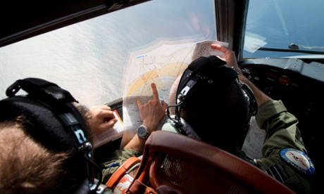
The commanding officer of Australia's HMAS Success, Captain Allison Norris, said she had instituted hourly shift changes to make sure crews' attention did not stray from scanning the vast and remote stretch of ocean notorious for its rapidly changing weather conditions. The warship is leading the seaborne search in a multinational effort that on Friday resumed with 10 aircraft setting out to join the five ships already at sea.
Norris told the Sydney Morning Herald that supervisors on the Success were constantly reminding crew "what they're there for and keeping them focused".
"Morale remains good despite the cold conditions," she said.
Amsa said that as well as the planes already involved, the Australian air force was putting another P3 Orion on standby in case of a debris sighting.
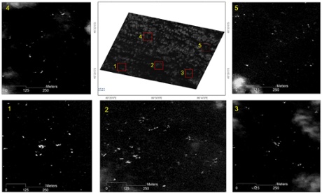
Thailand's Geo-Informatics and Space Technology Development Agency has said images taken on Monday showed about 300 objects ranging in size from two to 15 metres. The information was passed to Malaysian authorities.

It said the objects were scattered over an area about 2,700km (1,680 miles) south-west of Perth and about 200km from an area pinpointed earlier in French satellite photos. "But we cannot – dare not – confirm they are debris from the plane," said Anond Snidvongs, the executive director of the Thai space agency.
Japan also announced a satellite analysis indicated about 10 square floating objects in a similar area, the Kyodo news agency said. Japanese authorities said the objects were up to eight metres in length and four metres wide, with Jiji Press citing an official at the office as saying they were "highly likely" to be from the plane.
Martin Dolan, chief commissioner of the Australian Transportation Safety Bureau, said the original search zone had a range of possible assumptions about aircraft speed that had now been refined.
"It is an iterative process and is being refined over time but what we have at the moment is the most credible location of the entry to the water and therefore the place to search," he said.
Sorties being flown by planes from Australia, China, Japan and the United States were forced back to Perth on Thursday as thunderstorms and gale force winds swept through the southern Indian Ocean, although the five ships stayed put. Amsa said the air search was able to start again on Friday.
The Malaysia Airlines jet vanished on 8 March with 239 people on board after taking off from Kuala Lumpur and then inexplicably turning off its China-bound course. All contact was lost except for a series of "pings" from a transmitter on the plane to a satellite that were used to plot its probable course into the deep south of the Indian Ocean.
The arrival of sensitive tracking equipment to help locate the plane's "black boxes" offers a glimmer of hope for a breakthrough in what has become the biggest mystery in commercial aviation history.
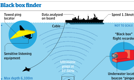
An Australian naval vessel ship will sweep the seabed by towing an underwater listening device deep below the surface in the hope of picking up an ultrasonic signal from one or both of the plane's black box recorders, while a small submersible drone will be used to scan the sea floor for signs of wreckage.

Search teams are hoping that the detection equipment will be able to pick up acoustic pings emitted every second from the plane's black box flight data recorder and cockpit voice recorder.
Each of the two recorders has a beacon, attached to the outside of the black box, which once activated by contact with water makes a sound every second. The beacons have a battery life of 30 days, sometimes longer, before the pings begin to fade. Assuming the plane crashed on 8 March, as Malaysian officials insist, that means the beacons aboard MH370 will begin to fade about 7 April and could go silent about 12 April.
Theories about the plane's fate include a hijacking, pilot sabotage or a crisis that incapacitated the crew and left the plane to fly on autopilot until it ran out of fuel.
The focus has been on the pilot, Captain Zaharie Ahmad Shah, with the FBI analysing data from a flight simulator taken from his home. So far no information implicating the captain or anyone else has emerged and his youngest son, Ahmad Seth, on Thursday dismissed speculation his father may have crashed the plane intentionally.
Agence France-Presse and AAP contributed to this report.
Source: http://www.theguardian.com

No comments:
Post a Comment